
Products
Refined and Drone-Optimized Solutions
For All Your Advanced Drone Requirements
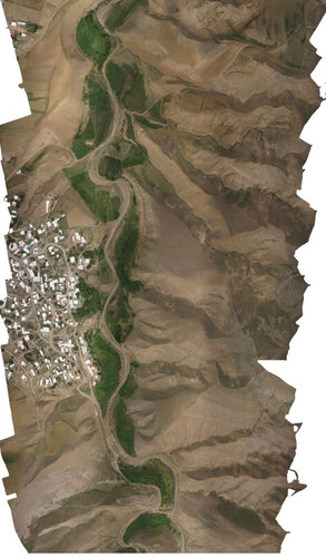
Experience the Flare Wings mapping drone, equipped with a distinctive array of features that enhance productivity, whether you’re in the field or analyzing data in the office.
Efficient Fixed-Wing Flight: Achieve speeds of up to 19 m/s (45 mph) and enjoy flight times of up to 90 minutes per flight, ensuring extensive coverage.
61 MP Camera: With a high-resolution 61 MP camera, Flare Wings surpasses drones limited to 20 MP cameras, enabling you to capture detailed images over larger areas per flight.
No More GCPs, Checkpoints Only: Say goodbye to the hassle of ground control points (GCPs) with our onboard high-precision PPK GNSS receiver. Just use three checkpoints to verify map quality.
Lower Image Overlaps: Thanks to our high-quality optics, reconstructing maps is reliable even with lower overlaps. This maximizes new ground coverage per flight line, delivering unparalleled mapping efficiency
Our Innovations
Specializing in Drone Industry Solutions
Flare Wings Photogrammetry FW90 RGB
Introducing Flare Wings Photogrammetry FW90 RGB: your ultimate aerial mapping solution. With cutting-edge technology and precision engineering, our FW90 RGB drone offers unparalleled accuracy in capturing high-resolution imagery for photogrammetry applications. From mapping terrain to surveying construction sites, our drone delivers reliable results with efficiency and ease. Trust Flare Wings for superior performance and exceptional quality in every flight
Flare Wings WaterLanding FW100H
Introducing the Flare Wings WaterLanding FW100H, an innovative solution for aquatic operations. Designed for seamless water landings, our FW100H drone offers exceptional stability and performance on water surfaces. With its robust design and advanced features, it’s ideal for various applications such as marine research, environmental monitoring, and search and rescue missions. Experience reliability and versatility with Flare Wings FW100H
Flare Wings Photogrammetry FW90+ LIDAR & Hyperspectral
Discover the Flare Wings Photogrammetry FW90+ equipped with LIDAR & Hyperspectral capabilities, revolutionizing aerial data collection. Our advanced drone combines state-of-the-art LIDAR technology with hyperspectral imaging, providing comprehensive insights for diverse industries. From detailed topographic mapping to precision agriculture analysis, our FW90+ delivers unparalleled accuracy and efficiency. Experience the future of aerial surveying with Flare Wings
Digitale AI plateform
Introducing our Digital AI Platform, the ultimate solution connecting drone pilots with clients in need of drone services. Our platform offers seamless integration, allowing pilots to effortlessly connect with potential clients and showcase their expertise. Additionally, our AI tools enable pilots to process aerial images captured by their drones efficiently. From automated analysis to generating detailed reports, our platform empowers pilots to deliver high-quality results to their clients with ease. Join us and elevate your drone services to new heights